Home » Themes » Technology » Agriculture
Tragowel Plains IrrigationPrint Page 
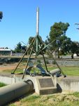
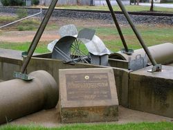
The monument commemorates one hundred years of irrigation development in the Tragowel Plains.
Location
| Address: | Victoria Street, Pyramid Hill, 3575 |
|---|---|
| State: | VIC |
| Area: | AUS |
| GPS Coordinates: | Lat: -36.055279 Long: 144.114982 Note: GPS Coordinates are approximate. |
Details
| Monument Type: | Monument |
|---|---|
| Monument Theme: | Technology |
| Sub-Theme: | Agriculture |
| Actual Event Start Date: | 26-April-1886 |
| Actual Event End Date: | 26-April-1986 |
Dedication
| Actual Monument Dedication Date: | Wednesday 2nd July, 1986 |
|---|
Tragowel Plains Irrigation Trust 1886.
Pyramid Hill Irrigation Area, Goulburn Murray Irrigation District.
Rural Water Commission of Victoria 1985.
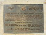
This plaque commemorates 100 years of irrigation development in the Tragowel Plains Area. Commenced on the 26th April, 1886, with the election of 15 Commissioners to the Tragowel Plains Irrigation Trust. First sod turned by the Governor of Victoria on 2nd July, 1886 in the water reserve 3 miles west of Pyramid Hill, now part of the Pyramid Hill No. 1 Channel. Development which followed was the fulfillment of Major Mitchell's vision of irrigation over these fertile plains - 29th June, 1836.
"They foresaw the benefits of irrigation"
Original Area : 219533 acres Current Area 119,915 Ha
Original price of Water : 6 pence per inch per acre Current Price $9.40 per megalitre. Water Right 1986 : 175,309 ML.
This plaque was unveiled by Deputy Chairman, Board of Management, Rural Water Commission of Victoria Mr. Duncan Malcolm on 2nd July, 1986.


