Home » Themes » People » Exploration
Matthew Flinders Print Page 
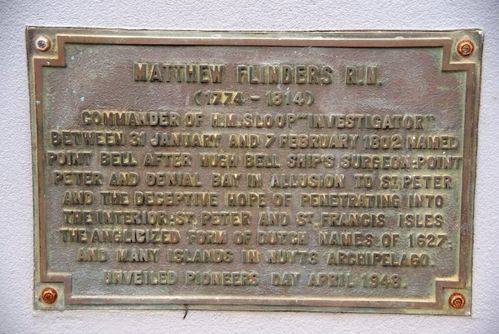
The plaque commemorates Matthew Flinders who explored the area in 1802. It is situated in the middle of the roundabout on the signpost obelisk.
Matthew Flinders on his voyage in the Investigator, anchored in Fowlers Bay on 28 January 1802. He went on to explore the coast and named Denial Bay, Smoky Bay and the islands of Nuyts Archipelago. He was disappointed to find no river and gave the name Denial Bay because they did not find fresh water.
A large crowd celebrated Pioneers' Day at Ceduna last week, when a plaque commemorating the arrival of Capt. Flinders was unveiled by Mrs. E. C. Lowe, one of the oldest pioneers in the district. Mrs. Lowe was introduced by Councillor E. C. Dahl, vice chairman of the District Council, who had charge of the proceedings.
Chronicle (Adelaide, SA), 6 May 1948.
Location
| Address: | Poynton & McKenzie Streets, Ceduna, 5690 |
|---|---|
| State: | SA |
| Area: | AUS |
| GPS Coordinates: | Lat: -32.126081 Long: 133.673789 Note: GPS Coordinates are approximate. |
Details
| Monument Type: | Plaque |
|---|---|
| Monument Theme: | People |
| Sub-Theme: | Exploration |
| Actual Event Start Date: | 21-January-1802 |
| Actual Event End Date: | 07-February-1802 |
Dedication
| Actual Monument Dedication Date: | Wednesday 28th April, 1948 |
|---|
Matthew Flinders R. N.
(1774 - 1814)
Commander of H. M. sloop " Investigator"
Between 31 January and 7 February 1802 named Point Bell after Hugh Bell Ships`s Surgeon :
Point Peter and Denial Bay in allusion to St. Peter and the deceptive hope of penetrating into the Interior :
St Peter and St Francis Isles the Anglicized form of Dutch names of 1627 ; and many islands in Nuyts Archipelago.
Unveiled Pioneers Day April 1948


