Home » Themes » Landscape » Settlement
Pioneer Memorial LogPrint Page 
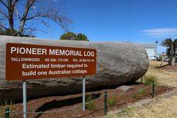
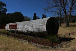
The large timber log commemorates the pioneers of the Dorrigo District.
By 1841, timber cutters had entered the Bellinger River searching for red cedar (Toona australis). They set up camps and moved from one stand of trees to the next.
Richard Craig, an escaped convict from the Moreton Bay Penal Settlement, was the first European to reach the Dorrigo Plateau, following the traditional indigenous route to Armidale from the Grafton area. Using his skills as a horseman, Craig travelled along the western side of the Nymboida River. Craig's track became a road, now roughly following the same path as the present Grafton to Armidale Road and travelling through the present day villages of Nymboida, Billy's Creek, Dundurrabin, Tyringham and Ebor. Timbergetters followed Craig through the sub tropical rainforest and many sawmills grew due to demand for timber, initially the highly prized Australian Red Cedar (Toona australis).
Today, the main access road traversing the plateau from east to west is the Waterfall Way. It was not until the 1860s that permanent settlement occurred in the district. The dairy industry became a mainstay of the Dorrigo Plateau and today tourism is becoming more important.
Location
| Address: | Hickory Street, Coronation Park , Dorrigo, 2453 |
|---|---|
| State: | NSW |
| Area: | AUS |
| GPS Coordinates: | Lat: -30.338531 Long: 152.712396 Note: GPS Coordinates are approximate. |
Details
| Monument Type: | Monument |
|---|---|
| Monument Theme: | Landscape |
| Sub-Theme: | Settlement |
Dedication
Pioneer Memorial Log


![30-September-2017 [Peter Williams] 30-September-2017 [Peter Williams]](https://monumentaustralia.org.au/content/directory/full/Pioneer_Memorial_Log-91962-109764.jpg)

![30-September-2017 [Peter Williams] 30-September-2017 [Peter Williams]](https://monumentaustralia.org.au/content/directory/thumb/Pioneer_Memorial_Log-91962-109764.jpg)


