Home » Themes » Landscape » Exploration
European Discovery of TasmaniaPrint Page 
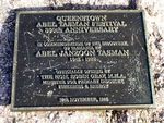
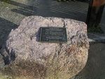
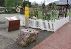
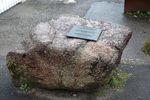
The plaque commemorates the 350th anniversary of the European discovery of Tasmania by Abel Tasman in 1642.
On 24 November 1642 Abel Tasman sighted the west coast of Tasmania, north of Macquarie Harbour. He named his discovery Van Diemen's Land after Antonio van Diemen, Governor-General of the Dutch East Indies. Proceeding south he skirted the southern end of Tasmania and turned north-east, Tasman then tried to work his two ships into Adventure Bay on the east coast of South Bruny Island where he was blown out to sea by a storm, this area he named Storm Bay.
Two days later Tasman anchored to the North of Cape Frederick Hendrick just North of the Forestier Peninsula. Tasman then landed in Blackman Bay – in the larger Marion Bay. The next day, an attempt was made to land in North Bay; however, because the sea was too rough the carpenter swam through the surf and planted the Dutch flag in North Bay. Tasman then claimed formal possession of the land on 3 December 1642.
Location
| Address: | Driffield Street, Railway Car Park, Queenstown, 7467 |
|---|---|
| State: | TAS |
| Area: | AUS |
| GPS Coordinates: | Lat: -42.078784 Long: 145.555467 Note: GPS Coordinates are approximate. |
Details
| Monument Type: | Plaque |
|---|---|
| Monument Theme: | Landscape |
| Sub-Theme: | Exploration |
| Actual Event Start Date: | 24-November-1642 |
| Actual Event End Date: | 24-November-1992 |
Dedication
| Actual Monument Dedication Date: | Sunday 29th November, 1992 |
|---|
QUEENSTOWN
ABEL TASMAN FESTIVAL
350th ANNIVERSARY
In Commemoration Of The Discovery
Of Tasmania By
ABEL JANZOON TASMAN
1642 - 1992
Officially Opened By
The Hon. Robin Gray, M. H. A.
Minister For Primary Industry,
Fisheries & Energy
29th November, 1992


