Home » Themes » Landscape » Exploration
Captain Charles Sturt Print Page 
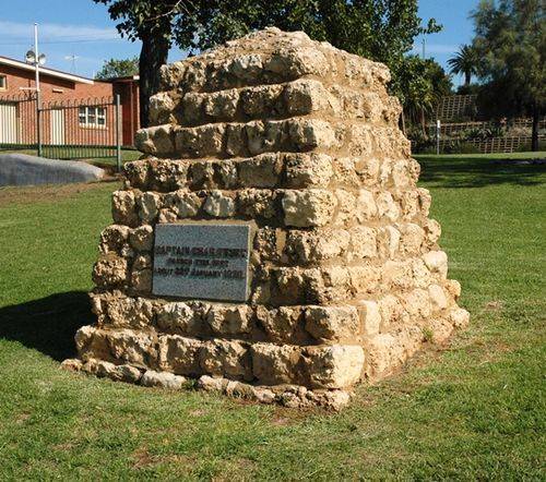
The cairn commemorates Captain Charles Sturt who passed Mildura during his exploration of the Murray River in 1830.
Captain Charles Napier Sturt (1795 – 1869) was a British explorer of Australia, and part of the European exploration of Australia. He led several expeditions into the interior of the continent, starting from both Sydney and later from Adelaide. His expeditions traced several of the westward-flowing rivers, establishing that they all merged into the Murray River. He was searching to determine if there was an "inland sea".
In January 1830 Sturt's party reached the confluence of the Murrumbidgee and a much larger river, which Sturt named the Murray River. Sturt then proceeded down the Murray, until he reached the river's confluence with the Darling. Sturt had now proved that all the western-flowing rivers eventually flowed into the Murray. In February 1830, the party reached a large lake which Sturt called Lake Alexandrina. A few days later, they reached the sea. There they made the disappointing discovery that the mouth of the Murray was a maze of lagoons and sandbars, impassable to shipping
In perfect weather a large gathering attended the unveiling of a memorial cairn to Captain Charles Sturt at Mildura. The cairn is of concrete and limestone, and bears a plate with the inscription : "Captain Charles Sturt passed this spot about 22nd January, 1830." The site chosen is on a lawn near the rowing club shed, facing the river, and near the weir. The official party was headed by Sir James Barrett, chairman of the Victorian Historical Memorials Committee, and included members of the committee. Mr. E. T Henderson, the acting mayor, presided, and welcomed the visitors. Addresses extolling Sturt 's voyages; were delivered by Messrs. Henderson, C. E. Long and Sir James Barrett.
Albury Banner and Wodonga Express (NSW), 17 January 1930.
Location
| Address: | Hugh King Drive, Murray River Bank, Mildura, 3500 |
|---|---|
| State: | VIC |
| Area: | AUS |
| GPS Coordinates: | Lat: -34.182179 Long: 142.165434 Note: GPS Coordinates are approximate. |
Details
| Monument Type: | Monument |
|---|---|
| Monument Theme: | People |
| Sub-Theme: | Exploration |
| Actual Event Start Date: | 22-January-1830 |
| Actual Event End Date: | 22-January-1830 |
Dedication
| Approx. Monument Dedication Date: | January-1930 |
|---|
Captain Chas. Sturt passed this spot about 22nd January 1830


