Home » Themes » Landscape » Exploration
Hume & Hovell Print Page 

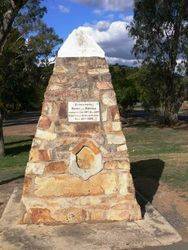
The cairn commemorates explorers Hume and Hovell who passed through the area in 1824. The cairn was unveiled in 1924, the centenary year of the exploration.
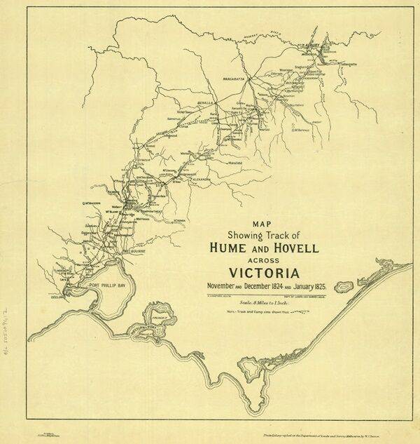
In 1824, Hamilton Hume and William Hovell led an expedition of discovery to find new grazing land for the colony. They and their party trekked south from Appin to Lake George, then on into Victoria, keeping west of the Great Dividing Range and ending up at Corio Bay, on the Victorian coast, where present day Geelong is situated. Hovell mistakenly believed they had arrived at Westernport, and did not realise his mistake until after his return.
At the centenary of Hume and Hovell exploration in 1924 a committee was formed to co-ordinate and organise local celebrations along the route from Albury to Corio Bay. An itinerary was created for the unveiling ceremonies giving the hour and date for each place concerned from 15 to 21 November 1924.
Monuments, cairns or plaques commemorating this expedition were erected at Allan`s Flat, Avenel, Back Creek, Barjarg, Bellbridge, Broadford, Bulla, Deer Park, Ebden, Euroa, Everton, Hansonville, Hume Reservoir, Kilmore, Lara, Lima South, Meadow Creek, Molyullah, Mount Buffalo, Moyhu, Murmungee, Myrtleford, Samaria, Samaria West, Seymour, Staghorn Flat, St Albans, Stanley, Strath Creek, Swanpool, Tatong (Dodd`s Crossing), Violet Town, Warrenbayne West, Werribee, Whorouly, Woodfield Yarck and Yea.
The location of the plaques erected at Lima South is unknown. It is believed that the plaque at Hansonville has come from another location as the date on the plaque does not match the date that the expedition was there.
HUME AND HOVELL CENTENARY. At the Melbourne committee rooms, on Friday, the committee in charge of the centenary celebrations of the Hume and Hovell explorations met to discuss the time-table for the unveiling of monuments along the route followed by the two pioneers. After much discussion, it was agreed that, with the co-operation of the Royal Automobile Club, the route followed would be as follows:— Starting from Bright on Sunday, 16th November, they will unveil a tablet at the foot of Mount Buffalo. On Monday they will proceed via Myrtleford, Whorouly, Everton, Murmungee, and Stanley, staying at Beechworth overnight. Tuesday’s program covers Back Creek, Allen’s Flat, Staghorn Flat, Ebden and Bethanga.
Tuesday evening and Wednesday will be spent at Albury, where a sports meeting and concert have been arranged. At Wangaratta the party will divide, the main party proceeding to Benalla, where a civic reception has been arranged. They will proceed through to Violet Town, Euroa, Avenel and Seymour. The remainder will proceed via Hedi, Hansonville, Samaria, and Swanpool to Merton. On the Friday this second party will travel from Avenel through Bonnie Doon and Yarck to Yea. The parties will re-unite at Broadford on the Friday and proceed to Melbourne. Sir J. Barrett (chairman) said the Education Department has arranged demonstrations by school children at all places included in the itinerary, and was making special efforts to interest the children in the history and development of the districts traversed by the explorers.
Upper Murray and Mitta Herald (Vic.), 25 September 1924.
Location
| Address: | Tarcombe Street & Kirkland Avenue East, Burton`s Bridge, Euroa, 3666 |
|---|---|
| State: | VIC |
| Area: | AUS |
| GPS Coordinates: | Lat: -36.753942 Long: 145.574952 Note: GPS Coordinates are approximate. |
Details
| Monument Type: | Monument |
|---|---|
| Monument Theme: | People |
| Sub-Theme: | Exploration |
| Actual Event Start Date: | 29-December-1824 |
| Actual Event End Date: | 29-December-1824 |
| Link: | https://www.sl.nsw.gov.au/stories/h… |
Dedication
| Actual Monument Dedication Date: | Thursday 20th November, 1924 |
|---|
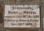
Explorers Hume and Hovell, passed this way 29th Dec.1824.
Erected by Shire of Euroa
Nov. 20th 1924


