Home » Themes » Landscape » Exploration
175th Anniversary European Discovery of the Hastings RiverPrint Page 
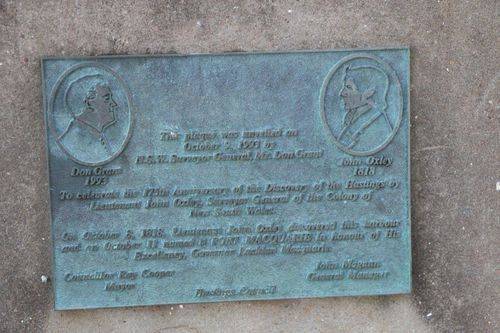
The plaque commmemorates the 175th anniversary of the European discovery of the Hastings River and the naming of Port Macquarie by Lieutenant John Oxley in 1818.
The river was first charted by European explorers in 1818, after its discovery by John Oxley who named the river for the then Governor General of India, Francis Rawdon-Hastings, 1st Marquess of Hastings.
Location
| Address: | Horton Street, Town Green, Port Macquarie, 2444 |
|---|---|
| State: | NSW |
| Area: | AUS |
| GPS Coordinates: | Lat: -31.428235 Long: 152.907882 Note: GPS Coordinates are approximate. |
Details
| Monument Type: | Plaque |
|---|---|
| Monument Theme: | Landscape |
| Sub-Theme: | Exploration |
| Actual Event Start Date: | 08-October-1818 |
| Actual Event End Date: | 11-October-1818 |
Dedication
| Actual Monument Dedication Date: | Saturday 9th October, 1993 |
|---|
Etching Etching
Don Grant 1993 John Oxley 1818
This plaque was unveiled on
October 9, 1993 by
N.S.W. Surveyor General, Mr. Don Grant
To celebrate the 175th Anniversary of the Discovery of the Hastings
by Lieutenant John Oxley, Surveyor General of the Colony of
New South Wales.
On October 8, 1818, Lieutenant John Oxley discovered the harbour
and on October 11 named it Port Macquarie honour of His
Excellency, Governor Lachlan Macquarie.
Councillor Ray Cooper Mayor
John Magann General Manager
Hastings Council


