Centre of New South WalesPrint Page 
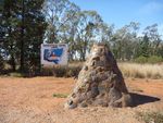
The cairn marks the geographical centre of New South Wales and was erected to commemorate the nation's bicentenary in 1988.
The cairn was constructed using slag from the old Mount Royal and the Bogan River Copper Mines.
Location
| Address: | Cockies Road, Five Ways, 42 kilometres west of Tottenham, Tottenham, 2873 |
|---|---|
| State: | NSW |
| Area: | AUS |
| GPS Coordinates: | Lat: -32.163191 Long: 147.032179 Note: GPS Coordinates are approximate. |
Details
| Monument Type: | Monument |
|---|---|
| Monument Theme: | Landscape |
| Sub-Theme: | Settlement |
Dedication
| Approx. Monument Dedication Date: | 1988 |
|---|
Australia
1788 - 1988
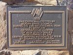
This cairn was erected by Bogan Shire Council during the 1988 Becentennial Year
To mark the geographical centre of New South Wales as determined by the Central Mapping Authority of N.S.W. by graphical digitisation.
J. G. Delaney J. J. Hoare R. P. Whatham
Shire Clerk Shire President Shire Engineer
Plaque :
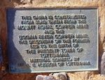
This cairn is constructed from slag taken from the Mount Royal Copper Mine and the Bogan River Copper Mine.
The discovery of the former led to the birth of the present town of Tottenham.
Material donated by Mr. A. E. Hudson of Tottenham.


