www.monumentaustralia.org.au


Henry DangarPrint Page 

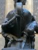
Henry Dangar Inscription


Photographs supplied by Diane Watson
The monument commemorates surveyor and explorer Henry Dangar (1796 - 1861) who camped near the site in 1824.
Dangar who was a surveyor and pastoralist was appointed assistant in the Survey Department and employed in the counties of Camden and Argyle. He transferred to Newcastle to make a detailed survey of the Hunter Valley and for the next two years measured and marked out in the Hunter River and as far north as Patrick`s Plains. He also marked the road from Newcastle to Wallis Plains (Maitland).
Location
| Address: | New England Highway & Segenhoe Street, Dangar Park, Aberdeen, 2336 |
|---|---|
| State: | NSW |
| Area: | AUS |
| GPS Coordinates: | Lat: -32.162963 Long: 150.890451 Note: GPS Coordinates are approximate. |
Details
| Monument Type: | Monument |
|---|---|
| Monument Theme: | People |
| Sub-Theme: | Exploration |
| Actual Event Start Date: | 01-August-1824 |
| Actual Event End Date: | 01-August-1824 |
Dedication
| Actual Monument Dedication Date: | Saturday 3rd August, 1974 |
|---|
Front Inscription
Source: MAHenry Dangar first explorer of the Upper Hunter River camped near this site on 1st August 1824.
Memorial erected by the residents of Aberdeen 3rd August 1974.
Plaque donated by Scone & U. H. Historical Society.
Monument details supplied by Monument Australia - www.monumentaustralia.org.au