www.monumentaustralia.org.au
Home » Themes » Conflict » World War Two
No. 131 Radar StationPrint Page 
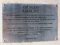
The plaque commemorates the operations undertaken by the No. 131 Radar Station on Ash Island from 16th December 1942 until 18th January 1946.
View Google Map
Location
| Address: | Millams Road, Kooragang Wetlands (Ash Island), Kooragang, 2304 |
|---|---|
| State: | NSW |
| Area: | AUS |
| GPS Coordinates: | Lat: -32.844607 Long: 151.697443 Note: GPS Coordinates are approximate. |
Details
| Monument Type: | Plaque |
|---|---|
| Monument Theme: | Conflict |
| Sub-Theme: | WW2 |
Dedication
| Actual Monument Dedication Date: | Tuesday 15th August, 1995 |
|---|
Front Inscription
Source: MA ASH ISLAND
RADAR SITE
This Plaque Commemorates The Operations Conducted By No. 131 Radar Station From 16th December 1942 Until 18th January 1946.
No. 131 Radar Station Was Located Here And Controlled The Fighter Aircraft Based At RAAF Base Williamtown.
No. 131 Radar Station Employed British MKV And Canadian RWG / GCI Radars.
This Plaque Is Presented By The Personnel Of No. 3 Control And Reporting Unit And The Radar Air Defence Branch Of The RAAF Association In Commemoration Of The 50th Anniversary Of Victory In The Pacific.
15th August 1995
Monument details supplied by Monument Australia - www.monumentaustralia.org.au


