Wills Massacre Print Page 


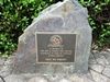
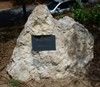
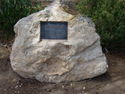
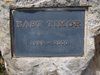
The graves and site commemorate the massacre of nineteen Europeans by Aborigines from the Kairi tribe on "Culling-La-Ringo" Station. This was the largest recorded massacre of Europeans in Australian history. Horatio Wills (station owner) and his people were buried in a grave at the scene of the massacre, which is remembered in a headstone.
It was a retaliatory massacre, part of the savage frontier guerrilla war that was being waged at the time. Eighty kilometres from Cullin-la-ringo and north of the Expedition and Staircase Ranges, some local graziers in 1861 were poisoning Kairi Kairi water holes and shooting Aboriginal people, while the Native Mounted Police were being encouraged to forcibly evict Aboriginal people from station and river camps.
Note: It is believed permission may be required to view this site. Ask at Springsure Visitor Information Centre in William Street for details.
 Horatio Wills Article 1921
Location
| Address: | Garden Creek Road, via Birtley Road, Springsure, 4722 |
|---|---|
| State: | QLD |
| Area: | AUS |
| GPS Coordinates: | Lat: -23.974234 Long: 147.910339 Note: GPS Coordinates are approximate. |
Details
| Monument Type: | Grave |
|---|---|
| Monument Theme: | Conflict |
| Sub-Theme: | Frontier |
| Actual Event Start Date: | 17-October-1861 |
| Actual Event End Date: | 17-October-1861 |
| Link: | https://c21ch.newcastle.edu.au/colo… |
Dedication
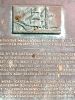
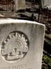
Headstone :
In
Memory Of
HORATIO SPENCER WILLS
Of Victoria
Aged 49 Years
Who With His Whole Party
Consisting Of 19 Persons, Men Women
And Children, Were Barbarously
Murdered By The Blacks On This
Spot On The 17th Of October
1861
Headstone :
R. I. P
GEORGE ELLIOTT
THOMAS
Killed By Blacks
17 - 10 - 1861
Headstone :
R. I. P
Mr. & Mrs. TOM BAKER
And Children
ELIZABETH, DAVID, IDEN
And Infant Daughter
Mr. & Mrs. PATRICK
And Children
MARY ANN, MAGGY
And Infant Daughter
Also GEORGE LING, EDWARD M`CORMACK, HENRY PICKERING
JAMES SCOTT & CHARLES WEEDON.
Killed By Blacks
17 - 10 - 1861
This is the site of the massacre of 19 people by a local Aboriginal tribe on 17 October 1861
The people killed were in a party led by Horatio Wills and were resting in the early afternoon when the tribe moved into camp and killed the ten men, two women and seven children