Home » Themes » Technology » Agriculture
Grain IndustryPrint Page 
The small coastal town of Balgowan near Maitland was once an important shipping port for the surrounding farming district. Its maritime history played a significant role in SA’s grain shipping era, but it wasn’t all smooth sailing for those involved.
First there was the original jetty, built in 1881, that was never used because of its location. Then, there were the grain chutes erected as a makeshift answer to the problem. Finally, graingrowers were granted an operational jetty in 1907.
Local author Stuart Moody knows the timeline all too well after conducting in-depth research and interviews with people in the shipping industry and the local farming community.
In the past 2.5 years he has documented every piece of evidence about the port – between 1870 and 1950- – and this month released a book which shares his findings, Balgowan the Outport.
Mr Moody said it was a dangerous, if not impossible, manoeuvre for the shipmasters to reach the jetty, and that not one bag of wheat was ever shipped from it. “Imagine being promised a jetty and then not being able to use it,” he said.
“It was all double and triple handling, and not all that efficient,” Mr Moody said.
And then, after 26 years, farmers saw the light at the end of the tunnel. A functional jetty was finally established, and several million bags were shipped out across the next 50 years. The jetty gradually fell into disrepair through the years, mainly due to storms and a lack of maintenance, before finally succumbing to a combination of a very high tide and gale force winds in 1981.
Stock Journal, 20 June 2016.
Location
| Address: | Schwartz Road & Main Street, Balgowan, 5573 |
|---|---|
| State: | SA |
| Area: | AUS |
| GPS Coordinates: | Lat: 34.323845 Long: 137.494545 Note: GPS Coordinates are approximate. |
Details
| Monument Type: | Plaque |
|---|---|
| Monument Theme: | Technology |
| Sub-Theme: | Agriculture |
Dedication
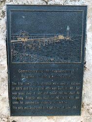
Commemorating the involvement
of Balgowan in the grain industry
The first township allotments were sold at auction
in 1879 and the original jetty was built in 1881 but
was sited over a reef and could not be used by
shipping. Another was built in 1907 and was last
used for commercial shipping in 1949 - 50.
The jetty was destroyed by a storm on 1st June 1981.


