www.monumentaustralia.org.au
Sir Paul Edmund de StrzeleckiPrint Page 
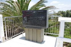
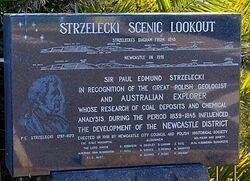
The Strzelecki Scenic Lookout was named in recognition of explorer and geologist Sir Paul Edmund de Strzelecki research into coal deposits and chemical analysis which influenced the development of the Newcastle District.
In December 1839 , after a visit to the Bathurst-Wellington district, Strezlecki stated to the geologists, W. B. Clarke and J. D. Dana, that the local mineralogy was `very tame`, a surprising statement in the light of later events. The field-work for his geological map took him in zigzags across New South Wales, and to the Australian Alps, where alone he ascended what he considered the highest peak, calling it after the Polish democratic leader, Tadeusz Kosciuszko.
In 1845 he became a British subject, and published in London his Physical Description of New South Wales and Van Diemen's Land, for which he received the founder's medal of the Royal Geographical Society. The book laid the basis of Australian palaeontology. Strzelecki thought it would be an important aid to the immigration of capital and men.
View Google Map
In December 1839 , after a visit to the Bathurst-Wellington district, Strezlecki stated to the geologists, W. B. Clarke and J. D. Dana, that the local mineralogy was `very tame`, a surprising statement in the light of later events. The field-work for his geological map took him in zigzags across New South Wales, and to the Australian Alps, where alone he ascended what he considered the highest peak, calling it after the Polish democratic leader, Tadeusz Kosciuszko.
In 1845 he became a British subject, and published in London his Physical Description of New South Wales and Van Diemen's Land, for which he received the founder's medal of the Royal Geographical Society. The book laid the basis of Australian palaeontology. Strzelecki thought it would be an important aid to the immigration of capital and men.
Location
| Address: | 43 High Street, Strzelecki Scenic Lookout, The Hill , 2300 |
|---|---|
| State: | NSW |
| Area: | AUS |
| GPS Coordinates: | Lat: -32.936631 Long: 151.777506 Note: GPS Coordinates are approximate. |
Details
| Monument Type: | Structure |
|---|---|
| Monument Theme: | People |
| Sub-Theme: | Science |
| Link: | http://adb.anu.edu.au/ |
Dedication
| Approx. Monument Dedication Date: | 1991 |
|---|
Front Inscription
Source: MA, ADBStrzelecki Scenic Lookout
Strzelecki`s diagram from 1845
[ Diagram ]
Newcastle in 1991
[ Diagram ]
Sir Paul Edmund de Strzelecki
In recognition of the great Polish geologist and Australian explorer whose research on coal deposits and chemical analysis, during the period 1839 - 1845 influenced the development of the Newcastle District
Erected in 1991 by Newcastle City Council and Polish Historical Society
The Right Worshipful the Lord Mayor Alderman John McNaughton
Aldermen
R. Robinson W. Bradley D. Lanham J. Tate
V.Bell D.Geddes D. Nichols A. Saunders
M. Goumas F. Rigby P. Wilson
Sec. Polish Historical Society M.Sc. H. Regulska-Slusarczyk
Monument details supplied by Monument Australia - www.monumentaustralia.org.au


