Home » Themes » People » Exploration
Nicolas BaudinPrint Page 
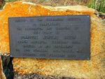
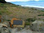
The plaque commemorates the charting of the coast by French navigator, Nicolas Baudin.
Baudin in 1800 proposed a scientific expedition to the south of New Holland and Van Diemen`s Land. Napoleon Bonaparte and the Institute of France, supported the scientific voyage and the gunship "Le Geographe" and the storeship "Le Naturaliste" sailed for New Holland.
In November 1801, with most of Baudin`s, crew becoming ill, he sailed directly for Van Diemen`s Land, entering d`Entrecasteaux Channel on January 13th 1802.
Location
| Address: | Esplanade, Swansea, 7190 |
|---|---|
| State: | TAS |
| Area: | Foreign |
| GPS Coordinates: | Lat: -42.126922 Long: 148.083383 Note: GPS Coordinates are approximate. |
Details
| Monument Type: | Plaque |
|---|---|
| Monument Theme: | People |
| Sub-Theme: | Exploration |
Dedication
| Actual Monument Dedication Date: | Saturday 27th February, 1960 |
|---|
Erected By The Tasmanian Society
To Commemorate
The Exploration And Charting Of
This Coast By
Commodore Nicolas Baudin
French Navigator, February 1802.
Unveiled By His Excellency
The Lord Rowallan K.T., K.B.E., M.C.
Governor. 27th February 1960


