Home » Themes » People » Exploration
Major Thomas Mitchell Print Page 
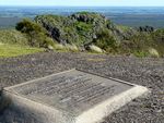
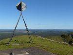
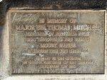
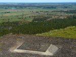
The plaque was erected by school children of the district to commemorate Major Sir Thomas Mitchell, who explored and named Mount Napier in 1836. The tablet was originally located on a caairn which has been removed.
On his third expedition in 1836, Mitchell explored the rich farming country of western Victoria, which he named "Australia Felix", or "Happy Australia". Prior to reaching this district, Mitchell found significant grazing land south of the Murray River. South of the Murray he discovered the Avoca and Glenelg Rivers. He then went on to explore the Campaspe and Wimmera Rivers and reached the coast near Cape Northumberland.
The memory of Major Mitchell was honored by a celebration at Buckley school and Mount Napier on Wednesday. At the school the Union Jack was unfurled, and on ascending the mount a similar function was performed. An inscribed tablet, built into a cairn 20 feet high, bearing the words, "Erected to the memory of Major Sir Thomas Mitchell, who discovered and named Mount Napier, 26th and 28th August, 1836," was unveiled by Mr Frank Tate, Director of Education.
Ararat Chronicle and Willaura and Lake Bolac Districts Recorder (Vic), 4 June 1915.
Location
| Address: | Mount Napier State Park, Mount Napier, 3301 |
|---|---|
| State: | VIC |
| Area: | AUS |
| GPS Coordinates: | Lat: -37.892808 Long: 142.058281 Note: GPS Coordinates are approximate. |
Details
| Monument Type: | Monument |
|---|---|
| Monument Theme: | People |
| Sub-Theme: | Exploration |
| Actual Event Start Date: | 12-August-1836 |
| Actual Event End Date: | 28-August-1936 |
Dedication
| Actual Monument Dedication Date: | Wednesday 2nd June, 1915 |
|---|
In memory of Major Sir Thomas Mitchell
Explorer of Australia Felix who discovered and named Mount Napier in August 12th and 28th 1836.
Erected in his honour by school children of the District
Discovery Day 1915.


