Home » Themes » Landscape » Exploration
Major Thomas Mitchell Print Page 
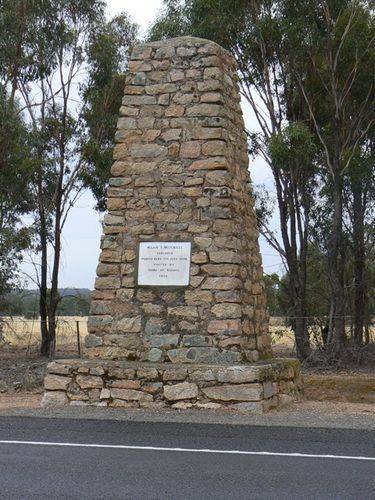
The cairn, erected by the Shire of Korong, commemorates Major Mitchell who passed through the area in 1836.
At the unveiling of the Bulla memorial for Hume and Hovell, Charles Daley the Secretary of the Victorian Historical Society suggested that the idea be extended to other explorers and a committee was formed to mark out the routes of Charles Sturt, Thomas Mitchell, Angus McMillan, and Count Paul de Strzelecki.
Thirty-five cairns or tablets to Mitchell were erected at Nyah West, Swan Hill, Cohuna, Mount Pyramid, Fernihurst, Wedderburn, Kanya, Stawell, Mount William, Horsham, Mount Arapiles, Miga Lake, Harrow, Coleraine, Casterton, Dartmoor, Isle of Bags, Portland, Mount Rouse, Mount Napier, Hamilton, Lake Repose, Dunkeld, Middle Creek, Mount Greenock, Mitchellstown, Nagambie, Castlemaine, Expedition Pass, Kyneton, Benalla, Wangaratta, Chiltern, Gooramadda and a public park at Natimuk (Major Mitchell Park, Mount Arapiles, Natimuk).
The goal of Mitchell's third expedition was to explore and survey the lower part of the Darling River, with instructions to head up the Murray River and return to Sydney via the settled areas around Yass. Second in command was assistant surveyor Granville Stapylton, and 23 convicts made up the rest of the party. He set out on 17 March 1836, and when passing Bathurst engaged a Wiradjuri aboriginal guide, John Piper.
Mitchell made his way to Boree and the Bogan River as on previous journeys, then veered south to the Lachlan River to approach the Darling from its southern end where it joined the Murray. At the end of June the country had improved considerably, so Mitchell chose to leave the Murray to investigate better looking lands to the south-west. Upon climbing the 91 metre Pyramid Hill, he was so impressed with the country he saw, he named it Australia Felix. In early July the party crossed the Loddon River, and made their way in a south-westerly direction which brought them to the Grampians, and later to the mouth of the Glenelg River on the coast.
Location
| Address: | Calder Highway, 5 kilometres south of Wedderburn, Wedderburn, 3518 |
|---|---|
| State: | VIC |
| Area: | AUS |
| GPS Coordinates: | Lat: -36.434582 Long: 143.639024 Note: GPS Coordinates are approximate. |
Details
| Monument Type: | Monument |
|---|---|
| Monument Theme: | People |
| Sub-Theme: | Exploration |
| Actual Event Start Date: | 07-July-1836 |
| Actual Event End Date: | 07-July-1836 |
Dedication
| Approx. Monument Dedication Date: | 1930 |
|---|
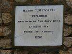
Major T. Mitchell explorer passed here 7th July 1836.
Erected by Shire of Korong
1930


