Home » Themes » Government » Local
City of Camberwell CentenaryPrint Page 
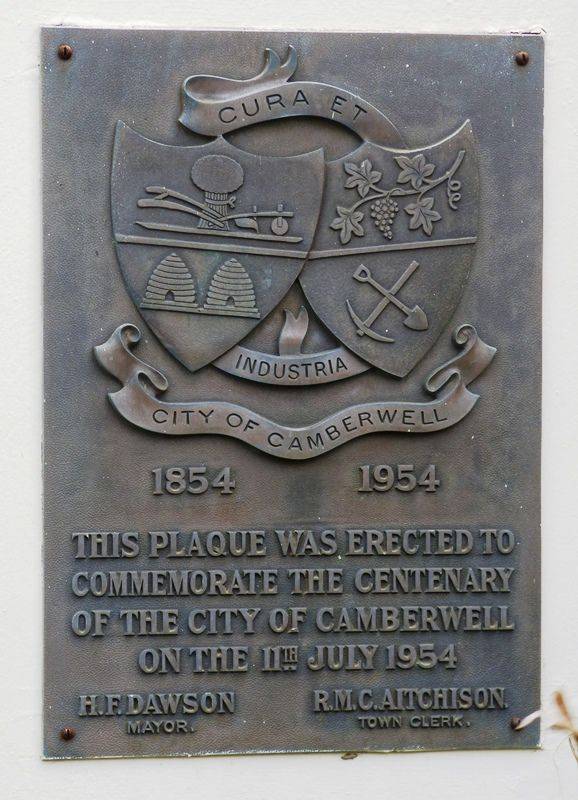
A plaque commemorates the centenary of the City of Camberwell.
Camberwell began its local government career as the Boroondara Road District on 11 July 1854. An area of 23.75 aquare miles comprised the districts of Camberwell, Hawthorn and Kew.
In 1890 Camberwell had 1200 buildings and 4416 people. Towards the end of 1952, there were 25667 buildings and a residential population of 98391. The 'Progress Press' of 14 July 1954 reported Camberwell's area of 14 square miles made it the third largest metropolitan area and the wealthiest council outside the City of Melbourne.
Location
| Address: | 340 Camberwell Road, Camberwell Civic Centre, Camberwell, 3124 |
|---|---|
| State: | VIC |
| Area: | AUS |
| GPS Coordinates: | Lat: -37.834761 Long: 145.060517 Note: GPS Coordinates are approximate. |
Details
| Monument Type: | Plaque |
|---|---|
| Monument Theme: | Government |
| Sub-Theme: | Local |
| Actual Event Start Date: | 11-July-1854 |
| Actual Event End Date: | 11-July-1954 |
Dedication
| Actual Monument Dedication Date: | Sunday 11th July, 1954 |
|---|
Cura Et
Industria
City of Camberwell
1854 - 1954.
This Plaque Was Erected To
Commemorate The Centenary
Of The City Of Camberwell
On The 11th July 1954.
H.F. Dawson R.M.C Aitchison
Mayor. Town Clerk.


