25th Anniversary of the 1974 Flood Print Page 

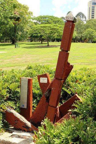
The memorial commemorates the 25th Anniversary of the 1974 flood.
Between 1870 and 1974, eight major floods swept though the gardens. The worst floods were in 1890, 1893, 1897 and 1974. In the 1974 flood, water rose up to 4.6 metres in the garden's centre. Whole plant collections were destroyed and the gardens closed for 10 weeks.
Location
| Address: | Alice Street, Botanic Gardens, Brisbane, 4000 |
|---|---|
| State: | QLD |
| Area: | AUS |
| GPS Coordinates: | Lat: -27.473516 Long: 153.029063 Note: GPS Coordinates are approximate. |
Details
| Monument Type: | Monument |
|---|---|
| Monument Theme: | Disaster |
| Sub-Theme: | Flood |
Dedication
| Approx. Monument Dedication Date: | 1999 |
|---|
Marker - 1974 Flood Level
In 1974 Brisbane was subjected to the worst flooding of the river since 1893. heavy rain began to fall on Friday 25th January and by satirday night 375mm had fallen in Brisbane. There were higher falls in inland parts of the catchment.
Vast areas of Brisbane were flooded and 14 lives were lost, 6700 homes ruined and 5000 people left homeless. The cost was almost $200 million. Those who were unharmed rallied to help those less fortunate. Few who live through the floods will forget them.
This marker was erected to commemorate the 25th anniversary of the 1974 floods. The marker shows the maximum level reached by the floodwaters in the City Botanic Gardens on the 29th January 1974. Large areas of the City adjacent to the Gardens were flooded.
Since the 1974 floods Wivenhoe Dam has been built on the Brisbane River near Fernvale. The dam was designed with excess capacity to store flood waters, and if it had been in place in 1974 the flood level here would be 1.5mm lower.
Each year the Council allocates substantial funds to regional and local drainage projects across the City to reduce the impact of flooding to residents.


