Home » Themes » Conflict » World War Two
Royal Australian Air Force Radar StationsPrint Page 

The plaque commemorates all who served in Royal Australian Air Force (R.A.A.F.) Radar Stations during World War Two.
A Radio Direction Finding station (RDF) arrived aboard the vessel Mako in November 1942. Radar was a new and secret technology at this point in the war and the Cooktown base was one of 32 ground stations to be established around Australia. The RDF was to be positioned on the open eastern spur of Grassy Hill, just below the Lighthouse, and as there was no road to the top of Grassy Hill at this time, erecting the facility was an arduous chore. The efforts however were well worth it and the siting was excellent for its purpose.
Location
| Address: | Hope Street , Grassy Hill, Cooktown, 4895 |
|---|---|
| State: | QLD |
| Area: | AUS |
| GPS Coordinates: | Lat: -15.460887 Long: 145.255079 Note: GPS Coordinates are approximate. |
Details
| Monument Type: | Plaque |
|---|---|
| Monument Theme: | Conflict |
| Sub-Theme: | WW2 |
Dedication
| Actual Monument Dedication Date: | Monday 2nd September, 1996 |
|---|
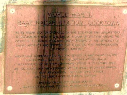
World War II
RAAF Radar Station Cooktown
No 56. Radar Station operated on this site from 28th Janaury 1843 to 8th January 1945. It was one of a chain of stations around the coast of Australia providing early warning of the approach of enemy aircraft and shipping and assisting with navigation for firendly aircraft.
This plaque commemorates all who served of RAAF Radar Stations during World War II in the defence of Australia.
It was donated by the then Commanding Officer Flt / Lt Frank Sharp and installed with the assistance of the Radar and Defence Branch of the RAAF Association, the Cook Shire Council and the James Cook Historical Museum.
Unveiled on the 2nd September 1996 by Warren Entsch MHR, Federal Member for Leichhardt


