www.monumentaustralia.org.au
Stradbroke Island Radar SitePrint Page 
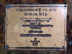
The plaque commemorates the No. 49 Radar Station which operated from the site as part of the air defence network defending Australia during World War Two.
View Google Map
Location
| Address: | Gorge Walk, Point Lookout, 4183 |
|---|---|
| State: | QLD |
| Area: | AUS |
| GPS Coordinates: | Lat: -27.435259 Long: 153.544108 Note: GPS Coordinates are approximate. |
Details
| Monument Type: | Plaque |
|---|---|
| Monument Theme: | Conflict |
| Sub-Theme: | WW2 |
| Actual Event Start Date: | 13-August-1943 |
| Actual Event End Date: | 15-April-1946 |
Dedication
Front Inscription
Source: MA STRADBROKE ISLAND
RADAR SITE
No. 49 Radar Station operated on this hill from
30th August 1943 to 15th April 1946
as part of the
Air Defence network defending Australia during
World War II.
Lest We Forget !
Erected by the Radar Branch RAAF Association QLD
Monument details supplied by Monument Australia - www.monumentaustralia.org.au


