Home » Themes » Landscape » Settlement
Bright Centenary CairnPrint Page 
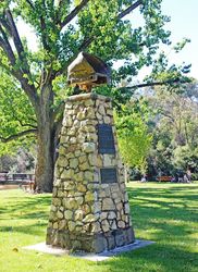
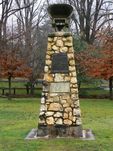
A cairn commemorates the centenary of the foundation of Bright.
Explored, like so much of Victoria, by Hume and Hovell in 1824, the first pastoral runs in the Bright area were taken up in the late 1830s - one of them by Hume`s brother-in-law, Dr Mackay, whose difficulties with the local Aborigines caused him to move to another property.
In 1845, Thomas Buckland established the area`s first cattle run near the river which was later to bear his name. The real development of the district began in 1853, when W.H. Pardoe discovered gold along the Buckland River. In 1861, the town became the administrative centre for the swelling population of the Buckland Gold District. Shortly afterwards, its name was officially changed to honour John Bright, a British liberal politician and advocate of free trade.
Location
| Address: | Mountbatten Avenue, Centenary Park, Bright, 3741 |
|---|---|
| State: | VIC |
| Area: | AUS |
| GPS Coordinates: | Lat: -36.726079 Long: 146.963659 Note: GPS Coordinates are approximate. |
Details
| Monument Type: | Monument |
|---|---|
| Monument Theme: | Landscape |
| Sub-Theme: | Settlement |
Dedication
| Actual Monument Dedication Date: | Saturday 10th March, 1962 |
|---|
Plaque :
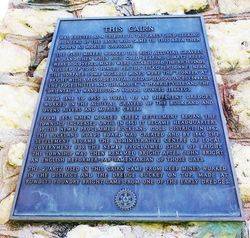
This Cairn was erected as a tribute to the early gold-seeking pioneers on the 1850`s, who came to this area then known as Morses Crossing.
The first miners worked the rich alluvial gravels by hand, then when rich gold-bearing quartz reefs were discovered, mines were established. The rich finds yielded up to 50 ounces per ton (1.5 kg per tonne) near the surface some notable mines were the "Pioneer" at Bright with a recorded total yield of 11,050 ounces (344 kg), the "Rose, Thistle and Shamrock" at Harrietville, and the "Oriental" at Wandiligong 60,000 ounces (1866 kg).
From 1898 to 1955 a total of 46 different dredges worked in the alluvial gravels of the Buckland and Ovens Rivers and Morse`s Creek.
From 1853, when Morse`s Creek settlement began, the township increased until in 1861 it became headquarters of the newly proclaimed Buckland Gold District. In 1862 the Buckland Roads Board was created and by 1866 the settlement became the administrative centre of local government for the newly proclaimed Shire of Bright. The township was then renamed Bright after John Bright an English reformer-parliamentarian of those days.
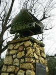
The quartz used in this cairn came from reef mines worked in the District, and the dredge bucket on top, made at Ruwolts Foundry Bright, came from one of the early dredges.
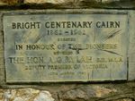
Plaque :
Bright Centenary Cairn
1862 - 1962
Erected in honour of the pioneers
Unveiled by the Hon. A. G. Rylah E.d, M.L.A. Deputy Premier of Victoria
10th March 1962


