Home » Themes » Landscape » Exploration
Elder Scientific Exploring ExpeditionPrint Page 

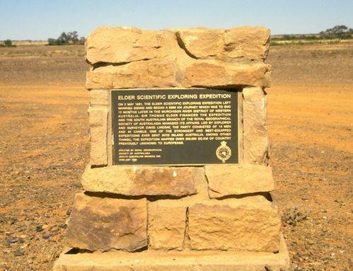
The memorial commemorates the Elder Scientific Exploring Expedition which set out from Warrina Siding in 1891 on their 6886 kilometre journey to Western Australia. This was possibly the most ambitious Australian expedition of all time.
Sir Thomas Elder financed the Expedition which was organised and run by the Royal Geographic Society, and was led by David Lindsay. It left the railway at Warrina, south of Oodnadatta, on 2 May 1891 on a journey that was to last twelve months. The party was one of the strongest and best equipped expeditions ever sent into inland Australia and consisted of 14 men (three of them scientists) and 44 camels.
Conditions for travel were favourable at first, with abundant feed and, fresh water. However, in mid-July the Expedition crossed into Western Australia and experienced very difficult drought affected country. Many of the surface waters considered permanent by earlier explorers like Giles, Gosse and Forrest had dried up. After a series of unsuccessful probes into the west and northwest, Lindsay decided to strike southwest to Giles` Queen Victoria Spring.
The Spring was reached on 23 September 1891 after one of the longest waterless forced marches in the history of Australian exploration, the camels having covered 868 kilometres on an allowance of only 36 litres of water per animal. They continued on to Fraser Range Station and recuperated before heading north to the Murchison River and the second phase of the Expedition. But the Expedition was dogged by psychological as well as physical problems and matters came to a head on 31 December with the resignation of the scientific officers.
Lindsay went to Geraldton and telegraphed the Society for further direction and on 20 January 1892 he was recalled to Adelaide. The Expedition continued eastwards to the Lake Carnegie area under the command of the surveyor, Lawrence Allen Wells. They discovered traces of gold at Lake Way which was soon to be the scene of the Wiluna Goldfield. Elder however, decided to terminate the Expedition on 4 March 1892 and Wells, returning to civilisation in the Murchison District, was notified by telegram that the Expedition was to be abandoned. The Expedition had also mapped over 200,000 square kilometres of country previously unknown to Europeans.
Location
| Address: | Oodnadatta Track , Warrina Siding, 95.5 kilometres south of Oodnadatta, Oodnadatta, 5734 |
|---|---|
| State: | SA |
| Area: | AUS |
| GPS Coordinates: | Lat: -28.191944 Long: 135.826389 Note: GPS Coordinates are approximate. |
Details
| Monument Type: | Monument |
|---|---|
| Monument Theme: | Landscape |
| Sub-Theme: | Exploration |
| Actual Event Start Date: | 02-May-1891 |
| Approx. Event Start Date: | |
| Actual Event End Date: | 04-March-1892 |
| Approx. Event End Date: |
Dedication
| Actual Monument Dedication Date: | Wednesday 22nd May, 1985 |
|---|
ELDER SCIENTIFIC EXPLORING EXPEDITION
On 2 May 1891, The Elder Scientific Exploring Expedition Left Warrina Siding And Began A 6886 Km Journey Which Was To End 12 Months Later In The Murchison River District Of Western Australia. Sir Thomas Elder Financed The Expedition And The South Australian Branch Of The Royal Geographical Society Of Australasia Managed Its Affairs. Led By Explorer And Surveyor David Lindsay, The Party Consisted Of 14 Men And 44 Camels, One Of The Strongest And Best-Equipped Expeditions Ever Sent Into Inland Australia. Among Other Things, The Expedition Mapped Over 200,000 Sq. Km Of Country Previously Unknown To Europeans
Erected By Royal Geographical
Society Of Australasia
(South Australian Branch) Inc.
22nd May 1985


