John Oxley Print Page 


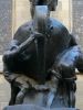
The cairn commemorates explorer John Oxley (1784 -1828) who camped near this spot on his exploration journey in 1818.
On 26 August 1818 the exploring party climbed a hill and saw before them rich, fertile land (Peel River), near the present site of Tamworth. Continuing further east they crossed the Great Dividing Range passing by the Apsley Falls on 13 September 1818 which Oxley named the Bathurst Falls. He described it as "one of the most magnificent waterfalls we have seen".
Upon reaching the Hasting River the exploring party followed it to its mouth, discovering that it flowed into the sea at a spot which Oxley named Port Macquarie.
Location
| Address: | Legge & Derby Streets, 750 metres south on Apsley River, Walcha, 2354 |
|---|---|
| State: | NSW |
| Area: | AUS |
| GPS Coordinates: | Lat: -30.988952 Long: 151.592843 Note: GPS Coordinates are approximate. |
Details
| Monument Type: | Monument |
|---|---|
| Monument Theme: | People |
| Sub-Theme: | Exploration |
| Actual Event Start Date: | 08-September-1818 |
| Approx. Event Start Date: | |
| Actual Event End Date: | 08-September-1818 |
| Approx. Event End Date: | |
| Link: | http://adb.anu.edu.au/ |
Dedication
John Oxley Surveyor General on his journey of exploration of the coast camped approximately 1 mile → S.E. of here
8th September, 1818