www.monumentaustralia.org.au


John Oxley ExpeditionPrint Page 

John Oxley Inscription : 31-Jul;y-2014


Photographs supplied by Diane Watson / Sandra Brown
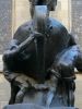
The memorial commemorates the exploration party led by Surveyor-General John Oxley who passed this spot in 1818. The memorial was erected as a project to commemorate the nation`s bicentenary in 1988.
Gulargambone is on the Castlereagh River, which was first discovered by the surveyor, G.W. Evans, of John Oxley's party, in 1818.
Location
| Address: | Castlereagh Highway, John Oxley Memorial Rest Area,12.5 kilometres north, Gulargambone, 2828 |
|---|---|
| State: | NSW |
| Area: | AUS |
| GPS Coordinates: | Lat: -31.226501 Long: 148.456802 Note: GPS Coordinates are approximate. |
Details
| Monument Type: | Monument |
|---|---|
| Monument Theme: | Landscape |
| Sub-Theme: | Exploration |
| Approx. Event Start Date: | 1818 |
| Approx. Event End Date: | 1818 |
Dedication
| Actual Monument Dedication Date: | Sunday 31st July, 1988 |
|---|
Front Inscription
Plaque:
Australia
1788 - 1988
N.S.W. Bicentennial Council
John Oxley Memorial
To commemorate the exploration party, led by John
Oxley - Surveyor General, of 16 men and 19 horses
which crossed in this vicinity 2nd August 1818.
Joint project funded by the N.S.W. Bicentennial Council,
Shire of Coonamble and Gulargambone Historical
Society.
Officially commemorated 31st July 1988
Inscription in Proximity
JOHN OXLEY 1818
Source: H, MAJOHN OXLEY 1818
Monument details supplied by Monument Australia - www.monumentaustralia.org.au