Naming of Norfolk PointPrint Page 
Lieutenant (later Captain) Matthew Flinders was the first explorer to enter Glass House Bay (now Moreton Bay). Having left Sydney on 8 July 1799 in HM Sloop Norfolk he reached Cape Moreton on 14 July. For two weeks he explored the bay and its environs. He named Port Skirmish, Pumice Stone River, and Red Cliffe Point (now South Point, Pumicestone Channel and Woody Point.) Finding that there was a passage (South Passage) from Glass House Bay to the ocean, he named the land to the north of it Moreton Island. Other islands he discovered were Mud, St Helena, Green, King, Peel and Coochie Mudlo Islands.
Location
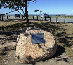
| Address: | Trafalgar Street, near Manly Boathouse, Manly, 4179 |
|---|---|
| State: | QLD |
| Area: | AUS |
| GPS Coordinates: | Lat: -27.451265 Long: 153.191217 Note: GPS Coordinates are approximate. |
Details
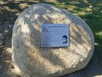
| Monument Type: | Plaque |
|---|---|
| Monument Theme: | Landscape |
| Sub-Theme: | Exploration |
Dedication
| Actual Monument Dedication Date: | Saturday 22nd July, 2000 |
|---|
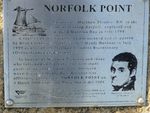
NORFOLK POINT
Lieutenant Matthew Flinders RN, in the
colonial sloop Norfolk, explored and
mapped Moreton Bay in July 1799.
A replica of the Norfolk commissioned and skippered
by Bern Cuthbertson AO, visited Manly Harbour in July
1999 as part of the Matthew Flinders Bicentenary
(Queensland) Celebrations.
In honour of Matthew Flinders and those
who followed in his wake, the man made
point at the eastern end of the northern
wave-break of Manly Boat Harbour was
officially gazetted as NORFOLK POINT on
3 March 2000 under the Place Names Act 1994.
This memorial plaque was erected 22 July 2000 as a
joint project of the Port of Brisbane Corporation and
the Wynnum Manly Historical Society Inc.
Port of Brisbane Corporation


