Home » Themes » Technology » Industry
Mary Kathleen Uranium LimitedPrint Page 
Mary Kathleen was a mining settlement in the northwestern part of Queensland, Australia. It was located in the Selwyn Range between Mount Isa and Cloncurry.
Mary Kathleen was first settled during the 1860s. Uranium was first discovered at Mary Kathleen by Clem Walton and Norm McConachy in 1954: the deposit and the township was named after the late wife of McConachy. Prospecting and exploitation rights were subsequently onsold, and in 1955 Rio Tinto Mining formed Mary Kathleen Uranium Ltd to develop a mine and service town. A sales contract with the United Kingdom Atomic Energy Authority was signed in 1956. Mining commenced at the end of 1956 and the treatment plant was commissioned in June 1958.
The project was developed by Mary Kathleen Uranium Limited (MKU) at a cost of A$24 million. MKU was formed to develop the uranium deposits and work was soon commenced constructing the township, mine, and dam on the nearby Corella River. The ore was mined by the open-cut method and processed on site. With all contracts filled by late 1982, the township, mine and mill were dismantled and the tailings rehabilitated by the end of 1984. Mary Kathleen became the site of Australia's first major rehabilitation project of a uranium mine, which was completed at the end of 1985 at a cost of some A$19 million.
Since rehabilitation, it has been found that the tailings repository at the Mary Kathleen site has been subject to seepage of radioactive waters from both the toe of the dam and the surface at rates much higher than initially predicted. The radioactive waste has seeped into former evaporation ponds as well as local drainage systems, causing widespread death of native vegetation. This issue remains unresolved.
Location
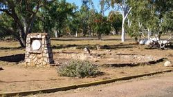
| Address: | Former Town Square, Mary Kathleen Abandoned Township, via Barkly Highway, Mary Kathleen , 4824 |
|---|---|
| State: | QLD |
| Area: | AUS |
| GPS Coordinates: | Lat: -20.777416 Long: 139.981511 Note: GPS Coordinates are approximate. |
Details
| Monument Type: | Plaque |
|---|---|
| Monument Theme: | Technology |
| Sub-Theme: | Industry |
Dedication
| Approx. Monument Dedication Date: | October-1958 |
|---|
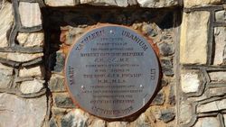
Mary Kathleen Uranium Ltd.
October 1958
This plaque was unveiled by the Right Honourable Robert Gordon Menzies C.H.,Q.C.,M.P. Prime Minister of Australia in the presence of the Hon G. F. R. Nicklin M.M., M.L.A. Premier of Queensland and other distinguished guests to commemorate the official opening


