Home » Themes » Landscape » Settlement
Settlement of "Burnewang Estate"Print Page 
The Minister for Lands (Mr Galvin) announced in Bendigo last week that he had signed an order-in-council for the compulsory acquisition of the Burnewang Estate, at Elmore, for utilisation in the soldier settlement plan. The Burnewang Estate is one of the best known properties north of Bendigo. The Minister stated he felt confident that with the construction of the Eppalock Weir there would be no more suitable area for soldier settlement than this Elmore property. Experts had reported that the land in the Elmore area was admirably suited for irrigation purposes, and compared more than favorably with other areas reserved for irrigation purposes.
Riverine Herald (Echuca, Vic. : Moama, NSW), 27 January 1947.
Location
| Address: | Burnewang Road, Burnewang, 3558 |
|---|---|
| State: | VIC |
| Area: | AUS |
| GPS Coordinates: | Lat: -36.467778 Long: 144.661944 Note: GPS Coordinates are approximate. |
Details
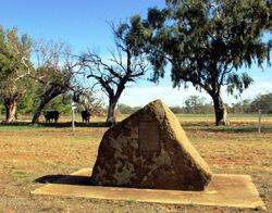
| Monument Type: | Plaque |
|---|---|
| Monument Theme: | Landscape |
| Sub-Theme: | Settlement |
| Approx. Event Start Date: | 1950 |
Dedication
| Approx. Monument Dedication Date: | 1999 |
|---|
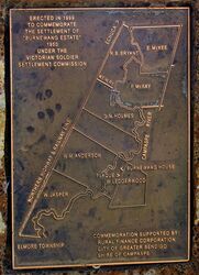
Erected In 1999
To Commemorate
The Settlement Of
"Burnewang Estate"
1950
Under The
Victorian Soldier Settlement Commission
[Map of Estate and Names]
Commemoration Supported By :
Rural Finance Corporation
City of Greater Bendigo
Shire of Campaspe


