Home » Themes » Landscape » Settlement
Silverton Memorial Stone WallPrint Page 
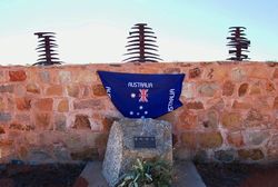
The stone wall commemorates the pioneers of Silverton. The sculptures on top of the wall are made from old miners picks.
The first European to visit the area was the then Surveyor General of New South Wales, Major Thomas Mitchell, in 1841. Three years later, in 1844, the explorer Charles Sturt saw and named the Barrier Range while searching for an inland sea; the range was so named as it was a barrier to his progress north. Burke and Wills passed through the area in their famous 1860-61 expedition, setting up a base camp at nearby Menindee. Pastoralists first began settling the area in the 1850s, with the main trade route to the area along the Darling River.
Prospectors began working in the area in 1867 when a local station-hand claimed to have found gold there. It was later discovered that his plan was merely a pretext for stealing a horse.
Some years later in 1875, two men drilling a well on a station south of the town site hit a lode of silver. Silverton was recognised as a town on 17 September 1880 and Richard O'Connell was sent in charge of the police. Among his many other duties was Acting Clerk of Petty Sessions, Mining Registrar and Warden's Clerk.
In October 1886 the Silverton Municipal Council was formed and held its inaugural meeting in January 1887 in the Silverton Municipal Chambers, which still exist. The town's population quickly increased reaching a peak around 3,000 in the 1890s, and the Silverton Tramway was opened in 1888 connecting the town to South Australia.
Many of the houses built were of simple iron and canvas construction. The rapid depletion of the high-grade ore around Silverton, along with the discovery of an even richer silver-lead-zinc ore body in nearby Broken Hill led to a sudden decline in Silverton's population, with many of those leaving taking their homes with them.
Location
| Address: | Silverton Cemetery, Silverton, 2880 |
|---|---|
| State: | NSW |
| Area: | AUS |
| GPS Coordinates: | Lat: -31.876308 Long: 141.230869 Note: GPS Coordinates are approximate. |
Details
| Monument Type: | Monument |
|---|---|
| Monument Theme: | Landscape |
| Sub-Theme: | Settlement |
| Designer: | Allen McLennan |
| Monument Manufacturer: | Allen McLennan |
Dedication
| Approx. Monument Dedication Date: | 2009 |
|---|
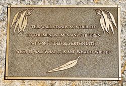
This Wall Stands As A Tribute
To The Men, Women And Children
Who Moulded Silverton Into
What It Was, What It Is And What It Will Be
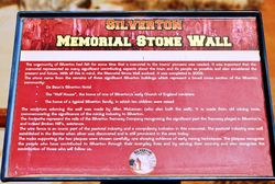
SILVERTON
MEMORIAL STONE WALL
The community of Silverton had felt for some time that a memorial to the towns` pioneers was needed. It was important that the memorial represented as many significant contributing aspects about the town and its people as possible and also considered the present and future. With all this in mind, the Memorial Stone Wall evolved. It was completed in 2009.
The stone came from the remains of three significant Silverton buildings which represent a broad cross section of the Silverton community :
- De Baun`s Silverton Hotel
- The "Half House", the home of one of Silverton`s early Church of England ministers
- The home of a typical Silverton family, in which ten children were raised
The sculpture adorning the wall was made by Allen McLennan (who also built the wall). It was made from old mining tools, commemorating the significance of the mining industry to Silverton. The footpaths represent the rails of the Silverton Tramway Compnay recognising the significant part the Tramway played in Silverton`s and indeed Broken Hill`s existence.
The wire fence is an iconic part of the pastoral industry and a compulsory inclusion in this memorial. The pastoral industry was well established in the Barrier when silver was discovered and is still prominent in the area today.
The rocks supporting the the two plaques were chosen carefully, one showing evidence of early mining techniques. The plaques recognise the people who have contributed to Silverton through their everyday lives and by serving their country and also recognise the contribution of those who will follow us.


