www.monumentaustralia.org.au
Home » Themes » Landscape » Settlement
Pioneers of Port ElliotPrint Page 
The Centenary Steps commemorate the pioneers of Port Elliot.
View Google Map
Freemans Nob was used as a lookout post for shore-base bay whaling stations in Encounter Bay in the late 1830s. The area was also used as a place to launch boats in 1842 for Hargan and Hart’s whaling station at Rosetta Head.
The port was established to provide a safe seaport for the Murray river trade which terminated at Goolwa as the Murray Mouth was deemed too treacherous and unpredictable for safe navigation. Goods and passengers were carried between Goolwa and Port Elliot on the first public railway in Australia completed in 1854.
Location
| Address: | The Strand, Port Elliot, 5212 |
|---|---|
| State: | SA |
| Area: | AUS |
| GPS Coordinates: | Lat: -35.536619 Long: 138.682532 Note: GPS Coordinates are approximate. |
Details
| Monument Type: | Structure |
|---|---|
| Monument Theme: | Landscape |
| Sub-Theme: | Settlement |
Dedication
| Approx. Monument Dedication Date: | 1936 |
|---|
Left Side Inscription
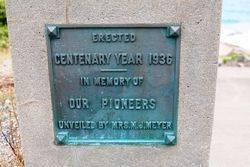
Erected
Centenary Year 1936
In memory of our pioneers
Unveiled by Mrs. M. J. Meyer
Right Side Inscription
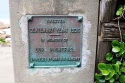
Source: MAErected
Centenary Year 1936
In memory of our pioneers
Unveiled by Mrs. H. H. Handby
Monument details supplied by Monument Australia - www.monumentaustralia.org.au


